NWS forecast: Rain before 2am, then rain and a slight chance of thunderstorms. Cloudy, with a low around 53. Southwest wind 5 to 10 mph. Chance of precipitation is 100%. New rainfall amounts between a quarter and half of an inch possible. Davis VP+ forecast:Not available
Sunday
Light Rain
Hi 63 °F
NWS forecast: Rain and a slight chance of thunderstorms before 5pm. Partly sunny, with a high near 63. West southwest wind 10 to 15 mph, with gusts as high as 25 mph. Chance of precipitation is 100%. New rainfall amounts between a tenth and quarter of an inch possible.
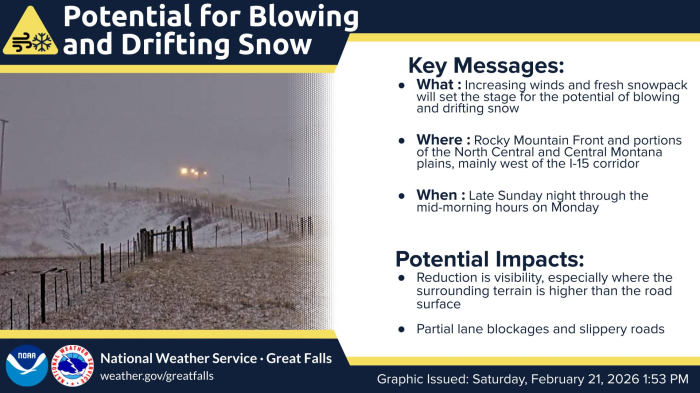
An upper level disturbance moving across the Northern Rockies through Monday will spread lower elevation rain showers and mountain snow showers across Southwest, Central, and portions of North Central Montana from the afternoon hours today through Monday evening/night. At this time the heaviest precipitation is expected to fall across Central and portions of North Central Montana, generally along and southeast of a Bynum, to Conrad, to Inverness line and north of the US Hwy 12 corridor from MacDonald Pass to White Sulphur Springs. Those traveling over mountain passes should be prepared for slushy roads at times, especially from the late evening tonight through Monday morning.
Data Courtesy of Great Falls Weather Forecast Office