Heat Advisory HEAT ADVISORY - Camarillo
Wind Advisory WIND ADVISORY - Camarillo

NWS Southwest Regional Radar WU South West Satellite
Radar/Satellite images courtesy of NOAA/NWS and Weather Underground.
spacer
Updated: @ 11-Mar-2026 5:10am - next update at 5:12am  
Summary / Temperature Wind Rain Outlook
Clear Clear
Currently: 49.7, Max: 52.0, Min: 49.7 49.7°F
Colder 0.2°F than last hour.

Cool

Feels like: 49°F

24-hr difference
-1.9°FColder 1.9°F than yesterday at this time.
  Today Yesterday
High: 52°F
12:00am
67.4°F
5:00pm
Low: 49.7°F
5:07am
51.5°F
4:43am
 Wind from ENE ENE
4
Gust:
8 mph
1 Bft - Light air
Today: 10 mph 3:35am
Gust Month: 30 mph March 8
Rain Today: 0 in
Rain Rate (/hr): 0 in
Rain Yesterday: 0 in
This Month: 0 in
Season Total: 5.62 in
19 days since last rain.
Wednesday

Wednesday: Patchy Fog then Mostly Sunny
Patchy Fog then Mostly Sunny
Humidity & Barometer Almanac Moon
Humidity: 88 %  
Dew Point: 46.3°F Decreased 0.4°F since last hour.
Barometer: 30.2 inHg Falling 0.01  inHg/hr
Baro Trend: Falling slowly
Sunrise: 7:10am
Sunset: 7:01pm
Moonrise: 2:24am
Moonset: 11:51am
Waning Crescent
Waning Crescent, Moon at 21 days in cycle
49%
Illuminated
UV Index Forecast UV Index Forecast
11-Mar-2026
5.6     Medium 
12-Mar-2026
6.1     High 
 NWS Weather Forecast  - Outlook: Overnight & Wednesday
Overnight

Overnight: Patchy Fog
Patchy Fog

Lo 49 °F
NWS forecast: Patchy fog after 5am. Partly cloudy, with a low around 49. East northeast wind 0 to 5 mph.
Davis VP+ forecast: Increasing clouds with little temperature change. Precipitation possible within 24 to 48 hours.
 
Wednesday

Wednesday: Patchy Fog then Mostly Sunny
Patchy Fog then Mostly Sunny

Hi 75 °F
NWS forecast: Patchy fog before 11am. Mostly sunny, with a high near 75. North northwest wind 0 to 10 mph.
Animated icons courtesy of www.meteotreviglio.com.
Countdown to Spring
 Vernal Equinox begins March 20th at 7:46am   PDT  


WEATHER STORY
Pendleton
Weather Forecast Office
Heavy Mountain Snow Expected Oregon Cascade and WA Blue Mtn Snow Strong Winds Wednesday Night and Thursday Morning
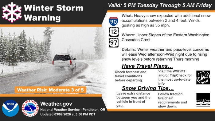
A Winter Storm Warning is in effect across the Upper Slopes of the Eastern Washington Cascades, bringing additional snow accumulations between 2 and 4 ft. Wind gusts are expected as high as 35 mph, which may also make for blowing snow at times. Hazardous winter weather and pass-level concerns are expected to ease from Wednesday afternoon through Wednesday night due to rising snow levels to 3,500-4,500 ft causing a changeover to a wintry mix or rain. However, hazardous winter weather conditions will return Thursday morning when snow levels drop down to 2,500-3,000 ft.

Data Courtesy of Pendleton Weather Forecast Office

San Juan, PR Lake Charles, LA Pueblo, CO Corpus Christi, TX St. Louis, MO Reno, NV Raleigh, NC  Newport/Morehead City, NC Dodge City, KS Houston/Galveston, TX San Joaquin Valley/Hanford, CA Louisville, KY Fort Worth, TX Pittsburgh, PA Austin/San Antonio, TX Sacramento, CA Jackson, MS Phoenix, AZ Northern Indiana, IN Flagstaff, AZ Tallahassee, FL Springfield, MO Riverton, WY Blacksburg, VA Sioux Falls, SD El Paso Area, NM Columbia, SC Wilmington, NC Greenville-Spartanburg, SC Eureka, CA Midland/Odessa, TX Tucson, AZ Goodland, KS Huntsville, AL Amarillo, TX Norman, OK Lubbock, TX Marquette, MI Little Rock, AR Pendleton, OR Missoula, MT Binghamton, NY Boston, MA Green Bay, WI Billings, MT Baltimore/Washington San Diego, CA Tampa Bay, FL Morristown, TN Twin Cities, MN Brownsville, TX Portland, OR Des Moines, IA Memphis, TN Pocatello, ID San Angelo, TX Jacksonville, FL Aberdeen, SD Quad Cities, IA/IL Charleston, SC New Orleans/Baton Rouge, LA Peachtree City, GA Shreveport, LA Grand Rapids, MI Medford, OR Albany, NY Wichita, KS Gray/Portland, ME Spokane, WA Boise, ID Denver/Boulder, CO Great Falls, MT Caribou, ME Key West, FL Miami-South Florida, FL New York City/Upton, NY Melbourne, FL Hastings, NE Paducah, KY Glasgow, MT Bismarck, ND Charleston WV Omaha/Valley, NE Buffalo, NY Jackson, KY Kansas City/Pleasant Hill, MO Gaylord, MI Cheyenne, WY Grand Forks, ND Detroit/Pontiac, MI Central Illinois, IL Burlington, VT Salt Lake City, UT Topeka, KS Nashville, TN Milwaukee/Sullivan, WI Albuquerque, NM Las Vegas, NV Wakefield, VA La Crosse, WI Birmingham, AL Los Angeles/Oxnard, CA Chicago, IL Seattle, WA Rapid City, SD Indianapolis, IN Philadelphia/Mount Holly, PA Mobile/Pensacola State College, PA Cleveland, OH Elko, NV Wilmington, OH Grand Junction, CO North Platte, NE Tulsa, OK San Francisco/Monterey Bay Area, CA Duluth, MN