NWS forecast: Rain after 5am. Mostly cloudy, with a low around 53. South wind 5 to 10 mph. Chance of precipitation is 80%. New rainfall amounts between a quarter and half of an inch possible. Davis VP+ forecast:Increasing clouds with little temperature change.
Saturday
Rain then Rain Showers Likely
Hi 60 °F
NWS forecast: Rain before 11am, then rain showers likely between 11am and 5pm. Mostly cloudy, with a high near 60. South southwest wind 5 to 10 mph, with gusts as high as 20 mph. Chance of precipitation is 80%. New rainfall amounts between a quarter and half of an inch possible.
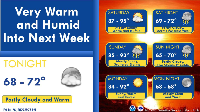
Tonight will be a quiet and cool period, before the weekend and Monday bring unsettled weather to the area. After lows tonight in the mid to upper 30s, a warming trend is in store Saturday through Monday. After potentially multiple rounds of showers and thunderstorms, some of which could be strong to severe, Tuesday looks dry and cooler. Monday is likely to be the warmest day, with highs in the mid 70s to mid 80s, but it also has the greatest risk of afternoon and evening severe thunderstorms.
Data Courtesy of Sioux Falls Weather Forecast Office